Dynamic of drown or flooded salt mines and their Caprock - geomechanical modelling
Dynamic of drown or flooded salt mines and their Caprock - geomechanical modelling
project executing organisation: Federal Ministry of Education and Research (BMBF)
project number: 02C1486
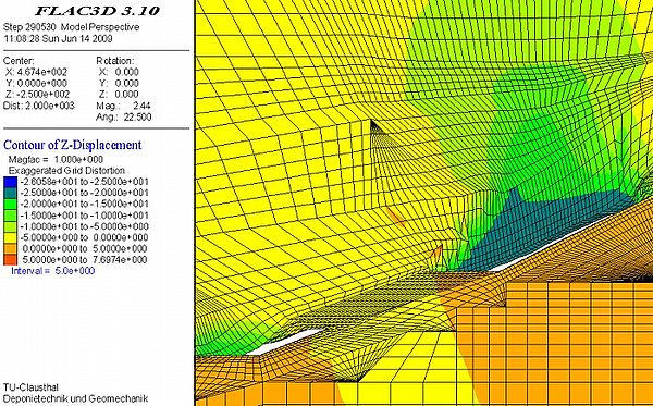
The Staßfurt location is characterized by surface subsidence and caves to the surface (sinkholes) due to collapse and drown of potash mines in the past. Solution of rock salt and potash occurs over decades of years, induced by fresh water circulation through the drown salt deposit and generates continuing surface subsidence and sinkholes. In order to predict surface development in the future geomechanical calculation based on numerical methods are done. Basic demands for a sufficient calculation of future surface subsidence are the acknowledgment of the geologic underground structure, the material behaviour of the rock mass, the geometry of underground excavations, a time schedule of mining operation events such as excavation, collapse, flooding, caves to surface, etc. and last but not least applicable criteria to decide weather or not the load bearing behaviour is leading in a rupture of rock mass. Taken into account the foresaid demands a geomechanical calculation model could be prepared and based on sensitivity studies a numerical recalculation of the measured surface subsidence could be done. Additionally to the numerical recalculation of the measured surface subsidence induced by convergence processes as well as failure processes in an old mining area it could be shown, that geomechanical calculations are applicable to verify the given data of the geological and tectonic structure as ell as the mining situation concerning the volume of underground openings caused by excavation or leaching.